


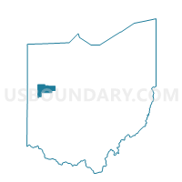
NOBLE Voting District, Auglaize County, Ohio
About
Outline

Summary
| Unique Area Identifier | 642855 |
| Name | NOBLE Voting District |
| County | Auglaize County |
| State | Ohio |
| Area (square miles) | 29.43 |
| Land Area (square miles) | 29.30 |
| Water Area (square miles) | 0.12 |
| % of Land Area | 99.58 |
| % of Water Area | 0.42 |
| Latitude of the Internal Point | 40.58791290 |
| Longtitude of the Internal Point | -84.39822820 |
Maps


Graphs
Select a template below for downloading or customizing gragh for NOBLE Voting District, Auglaize County, Ohio


Neighbors
Neighoring Voting District (by Name) Neighboring Voting District on the Map
- CENTER TOWNSHIP Voting District, Mercer County, OH
- EAST JEFFERSON NORTH Voting District, Mercer County, OH
- LOGAN Voting District, Auglaize County, OH
- MOULTON Voting District, Auglaize County, OH
- SALEM Voting District, Auglaize County, OH
- ST. MARYS 1A Voting District, Auglaize County, OH
- ST. MARYS 2B Voting District, Auglaize County, OH
- ST. MARYS 4A Voting District, Auglaize County, OH
- ST. MARYS E Voting District, Auglaize County, OH
- ST. MARYS W Voting District, Auglaize County, OH
Top 10 Neighboring County Subdivision (by Population) Neighboring County Subdivision on the Map
- Jefferson township, Mercer County, OH (13,155)
- St. Marys township, Auglaize County, OH (11,015)
- Noble township, Auglaize County, OH (1,716)
- Moulton township, Auglaize County, OH (1,694)
- Logan township, Auglaize County, OH (1,113)
- Center township, Mercer County, OH (1,086)
- Salem township, Auglaize County, OH (498)
Top 10 Neighboring Place (by Population) Neighboring Place on the Map
Top 10 Neighboring Unified School District (by Population) Neighboring Unified School District on the Map
Top 10 Neighboring State Legislative District Lower Chamber (by Population) Neighboring State Legislative District Lower Chamber on the Map
- State House District 78, OH (121,455)
- State House District 76, OH (120,854)
- State House District 77, OH (118,691)
Top 10 Neighboring State Legislative District Upper Chamber (by Population) Neighboring State Legislative District Upper Chamber on the Map
Top 10 Neighboring 111th Congressional District (by Population) Neighboring 111th Congressional District on the Map
- Congressional District 8, OH (663,644)
- Congressional District 4, OH (632,771)
- Congressional District 5, OH (627,799)
Top 10 Neighboring Census Tract (by Population) Neighboring Census Tract on the Map
- Census Tract 9675, Mercer County, OH (5,296)
- Census Tract 412.02, Auglaize County, OH (5,271)
- Census Tract 405, Auglaize County, OH (5,021)
- Census Tract 9673, Mercer County, OH (4,417)
- Census Tract 406, Auglaize County, OH (3,851)
- Census Tract 9676, Mercer County, OH (2,785)
- Census Tract 412.01, Auglaize County, OH (1,893)